| Function | Reference Model | Input/Output Data |
| SubAIMs | JSON Metadata | Profiles |
Function
The Visual Spatial Reasoning AIM (PGM‑VSR) AIM processes the visual portion of the spatial environment to detect, analyse, and describe objects, regions, and relevant visual features. It extracts structural, geometric, and motion‑related information from visual input and produces Visual Scene Descriptors that downstream AIMs use for Goal Acquisition and situational understanding. It acts as a bridge between raw visual scene descriptors and higher-level reasoning modules by interpreting and refining spatial visual context to support reasoning and action execution.
AIM-VSR
| Receives | Visual Action Directive | specifying how VSR should configure its visual‑processing pipeline, including:
The directive modulates VSR’s acquisition, segmentation, and object‑tracking behaviour. |
| Context |
Current, unenhanced visual snapshot, used as the observational basis for updating its internally maintained, temporally coherent visual scene model
|
|
| Refines | Visual Scene Descriptors | Constructs and updates structured representations including:
|
| Aligns wijh | Domain Access | VSR refines descriptors by querying Domain Access, using domain knowledge to:
|
| Produces | VSD1 | Contains:
|
| Visual Action Status | Includes:
|
Table 1 describes this iterative loop. Note that User State is not explicitly mentioned in the iterative loop.
Table 1 – Iterative loop of Visual Scene Descriptors
| Phase | Inputs | Operation | Outputs | To |
| Directive intake | PGM‑VAD (Visual Action Directive) | Conform pipeline: select required spatial operations, constraints, and priorities. | Conformance plan (internal) | — |
| Initial refinement | VSD0 (from OSD‑VSD), conformance plan | Produce VSD1 aligned to directive: descriptor parsing, normalisation, preliminary localisation. | VSD1 | PGM‑DAC |
| Domain enrichment | VSD1 | Apply domain‑specific knowledge, resolve ambiguities, add semantic attributes. | VSD2 | PGM‑VSR |
| Directive‑aligned reasoning | VSD2, conformance plan | Execute directive‑scoped spatial reasoning: refined localisation, depth/occlusion, affordance inference, salience mapping. | VSD3 | PGM‑DAC |
| Potential refinement loop | VSD3 | Domain Access may be called for additional Domain Knowledge | VSD3‘ | PGM-VSR |
| Transmission to OGM-PRC | VSD3‘ | VSD3‘ | PGM-PRC | |
| Status reporting | Conformance plan, execution results | Summarise compliance, coverage, uncertainties, and residual constraints | PGM‑VSR (Visual Action Status) | PGM‑AUC |
Specific functionalities
Visual Signal Acquisition: The VSR AIM receives visual data (e.g., frames, depth maps, or equivalent visual inputs) from the system’s perceptual acquisition pipeline.
Object and Region Detection: The VSR AIM identifies objects, regions, and salient visual structures within the visual scene using detection, segmentation, or classification processes.
Spatial and Geometric Feature Extraction: The VSR AIM extracts geometric and spatial features, including object position, orientation, size, movement vectors, and relative distances between visual elements.
Visual Scene Descriptor Generation: The VSR AIM generates Visual Scene Descriptors that describe the structure and content of the visual environment. Descriptors may include object identities or classes, spatial coordinates, region boundaries, and visual attributes.
User Gaze and Gesture Alignment: The VSR AIM detects and describes gaze direction, pointing gestures, line‑of‑sight alignment, and other visually observable indicators of Human focus or attention.
Temporal Structuring of Visual Observations: The VSR AIM organises visual descriptors over time, preserving temporal continuity, motion information, and relationships between successive frames.
Support for Deictic Reference Preservation: The VSR AIM preserves visual markers relevant to referenced expressions (e.g., identifying which object or region a Human appears to reference), without performing any semantic interpretation.
Environmental Robustness: The VSR AIM maintain descriptor accuracy by processing visual input robustly under variations in lighting, occlusions, motion blur, and other environmental conditions.
Reference Model
Figure 1 gives the Reference Model of the Visual Spatial Reasoning (PGM-VSR) AIM.
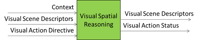
Figure 1 – The Reference Model of the Visual Spatial Reasoning (PGM-VSR) AIM
Input/Output Data
Table 2 gives the Input and Output Data of PGM-VSR.
Table 2 – Input/Output Data of PGM-VSR
| Input | Description |
| Context | A structured and time-stamped snapshot representing the initial understanding that the A-User achieves of the environment and of the User posture. |
| Visual Scene Descriptors | A modification of the input Visual Scene Descriptors provided by the Domain Access AIM to help the interpretation of the Visual Scene by injecting constraints, priorities, and refinement logic. |
| Visual Action Directive | Visual-related actions and process sequences from PGM-AUC. |
| Output | Description |
| Visual Scene Descriptors | A structured, analytical representation of the Visual Scene with object geometry, 3D positions, depth, occlusion, and affordance data. It highlights salient objects, normalised positions, proximity, and interaction cues. |
| Visual Action Status | Visual spatial constraints and scene anchoring from PGM-AUC. |
SubAIMs
Figure 2 gives the Reference Model of the Visual Spatial Reasoning (PGM-VSR) Composite AIM.
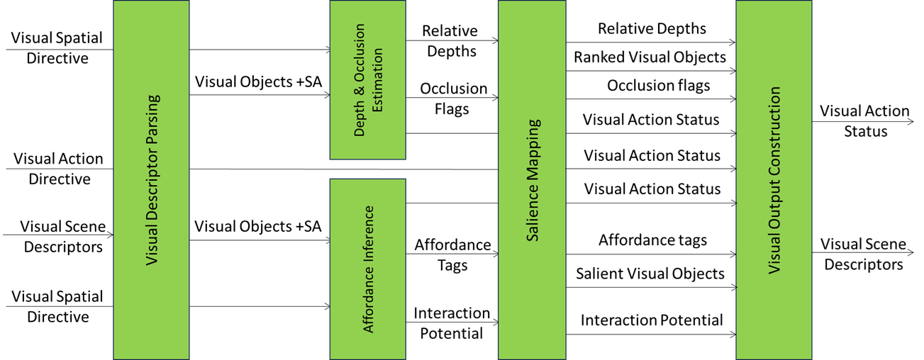 Figure 2 – Reference Model of Visual Spatial Reasoning (PGM-VSR) Composite AIM
Table 3 specifies the Functions performed by PGM-VSP AIM’s SubAIMs in the current example partitioning in SubAIMs.
Table 3 – Functions performed by PGM-VSP AIM’s SubAIMs (example)
| VDP | Visual Descriptors Parsing | Purpose | Decompose initial VSD into structured components and validate scene integrity. |
| Tasks | • Extract Visual Objects (VIO) and Object Spatial Attitudes (OSA: position, orientation, scale).
• Normalize coordinates to A-User PointOfView. • Validate descriptor completeness and schema compliance. • Maintain references for multimodal fusion. |
||
| Output | • Structured VIO list with OSA metadata.
• Validation report with confidence and uncertainty flags. |
||
| DOE | Depth and Occlusion Estimation | Purpose | Compute relative depth and occlusion relationships among visual objects to support spatial reasoning and safe interaction planning. |
| Tasks | • Estimate object distance from PointOfView using depth maps, stereo disparity, or scene geometry.
• Normalize depth values across heterogeneous sources and align with A-User coordinates. • Detect occlusion relationships and compute occlusion ratios. • Attach visibility status (VISIBLE, PARTIAL, HIDDEN) and confidence scores. • Integrate proximity zones (near/mid/far) for salience and rendering decisions. |
||
| Output | • DepthProfile: {objectID, depthValue, confidence, proximityZone}.
• OcclusionMap: {objectID, occludedBy[], occlusionRatio, visibilityStatus}. • Metadata: PointOfView, EnrichmentTime, AIM ID. |
||
| AFI | Affordance Inference | Purpose | Determine actionable properties and interaction potential of objects. |
| Tasks | • Infer affordances (graspable, clickable, draggable) from geometry and semantics.
• Cross-check inferred affordances against Rights and Rules. • Attach confidence scores and safety flags. |
||
| Output | • AffordanceProfile per object: {actions[], constraints, safetyFlags, confidence}. | ||
| VSM | Visual Salience Mapping | Purpose | Rank objects by prominence and relevance for interaction. |
| Tasks | • Compute salience using visual cues (size, contrast, motion) and depth from DOE.
• Integrate User gaze/gesture and A-User Control directives. • Filter non-salient entities to optimize reasoning and rendering. |
||
| Output | • RankedVisualObjects list with salience scores and rationale. | ||
| VOC | Visual Output Construction | Purpose | Aggregate enriched visual data into a coherent VSD₁ for downstream AIMs. |
| Tasks | • Merge outputs from VDP, DOE, AFI, and VSM.
• Attach metadata: PointOfView, EnrichmentTime, AIM ID. • Serialize VSD₁ for interoperability with Domain Access. |
||
| Output | • VSD₁: enriched Visual Scene Descriptor ready for Domain Access. |
Table 4 gives the AIMs composing the Visual Spatial Reasoning (PGM-VSR) Composite AIM:
Table 4 – AIMs of the Visual Spatial Reasoning (PGM-VSR) Composite AIM
| AIM | AIMs | Names | JSON |
| PGM-VSR | Visual Spatial Reasoning | Link | |
| PGM-ADP | Visual Descriptors Parsing | Link | |
| PGM-DOE | Depth and Occlusion Estimation | Link | |
| PGM-AFI | Affordance Inference | Link | |
| PGM-SMP | Visual Salience Mapping | Link | |
| PGM-VOC | Visual Output Construction | Link |
Table 5 gives the input and output data of the PGM-VSR AIM.
Table 5 – Input and output data of the PGM-VSR AIM
| AIMs | Input | Output | To |
| Visual Descriptors Parsing | Visual Scene Descriptors | Visual Objects Spatial Attitude |
DOE, AFI, SMP, VOC |
| Depth and Occlusion Estimation | Visual Objects Spatial Attitude Visual Spatial Directive |
Relative Depths Occlusion Flags Visual Spatial Status |
SMP, VOC |
| Affordance Inference | Visual Objects Spatial Attitude Visual Action Directive |
Affordance Tags Interaction Potential Visual Spatial Status |
SMP, VOC |
| Salience Mapping | Relative Depths Occlusion Flags Affordance Tags Interaction Potential Visual Action Directive |
Relative Depths Occlusion Flags Ranked Visual Objects Affordance Tags Interaction Potential Salient Visual Objects Visual Spatial Status |
VOC |
| Visual Output Construction | Relative Depths Occlusion Flags Ranked Visual Objects Affordance Tags Interaction Potential Salient Visual Objects Visual Spatial Status |
Visual Scene Descriptors Visual Spatial Status |
— |
Table 6 specifies the External and Internal Data Types of the Visual Spatial Reasoning AIM.
Table 6 – External and Internal Data Types identified in Visual Spatial Reasoning AIM
| Data Type | Definition |
|---|---|
| VisualSceneDescriptors | – Final structured output containing all spatialised and semantically enriched visual data (input). – The product of the Composite AIM (output). |
| UserPointOfView | Contained in component Basic Visual Scene Descriptors. |
| VisualObjects | Structured list of Visual Objects extracted from the Visual Scene Descriptors. |
| SpatialAttitudes | Position, Orientation, and their first and second order D spatial attributes of each Visual Object, including . |
| DepthEstimates | Classification of each object’s relative depth (e.g., foreground, midground, background). |
| OcclusionFlags | Visibility classification of each object (e.g., fully visible, partially occluded, hidden). |
| AffordanceProfile | Actionable properties of visual objects (e.g., graspable, tappable, obstructive) and inferred interaction potential. |
| RankedVisualObject | Ordered list of visual objects prioritized by perceptual salience and interaction relevance. |
| FilteredSalientObjects | Subset of Ranked Visual Objects selected for inclusion in the OSD-VSD1. |
| VisualSpatialDirective | Dynamic modifier provided by Domain Access AIM. Injects constraints, priorities, and refinement logic into reasoning Sub-AIMs. |
| VisualSpatialStatus | Structured status report from directive-aware Sub-AIMs. Includes constraint satisfaction, override flags, and anchoring metadata. |
Tables 7 maps VSR Inputs/Outputs to Unified Messages.
Table 7 – VSR Inputs/Outputs mapped to Unified Messages
| VSR Data Name | Role | Origin / Destination | Unified Schema Mapping |
|---|---|---|---|
| Context | Input | From Context Capture (CXC) | Consumed by VSR as scene input; carried in Context; referenced via Envelope.CorrelationId; MUST include Trace.Origin and Trace.Timestamp. |
| Visual Scene Descriptors (modified) | Input | From Domain Access (DAC) | Directive → TargetAIM=VSR; constraints/priorities injected in Parameters/Constraints; correlation maintained. |
| Visual Action Directive | Input | From A‑User Control (AUC) | Directive → Operation for visual actions; scheduling via Priority; correlation via Envelope.CorrelationId. |
| Entity State | Input | From Context Capture (CXC) | If used by VSR: carried in Context, referenced as Entity State for posture/attention |
| Visual Scene Descriptors | Output | To DAC / PRC | Status → Result (structured scene representation: geometry, 3D positions, depth, occlusion, affordances); maintain Envelope.CorrelationId. |
| Visual Action Status | Output | To A‑User Control (AUC) | Status → State/Progress/Summary/Result; includes spatial constraints and anchoring; MUST include Trace.Origin and Trace.Timestamp. |
5. JSON Metadata
https://schemas.mpai.community/PGM1/V1.0/AIMs/VisualSpatialReasoning.json
6. Profiles
No Profiles